Massive axing of dense forests has come under the scanner of the exclusive satellite imagery trying to deconstruct Kashmir’s abnormal warming and weather patterns.
The satellite remote-sensing data collected by scientist Dr. Irfan Rashid has revealed that Kashmir has lost 18 per cent dense forests since 1990.
“For an ecologically fragile Himalayan region like ours, this is a humongous loss,” Dr. Rashid, a young scientist in the Department of Geoinformatics, told The Himalayan Post.
“That the dense forests of Kashmir are drastically declining can spell doom in the region.”
Dr. Rashid’s exhaustive investigation was the part of the team research having big names like Prof. Shakil Romshoo, Irshad Rather, Nuzhat Shahi, Khalid Omar Murtaza, Khalida Hassan and Abdul Rehman Yousuf.
The study driven by field trips and the use of Satellite data, Geographic Information System, Global Positioning System and Earth Observation concluded that Kashmir’s deep forest area has been either degraded or converted into sparse forest or scrublands during the 38-year observation period.
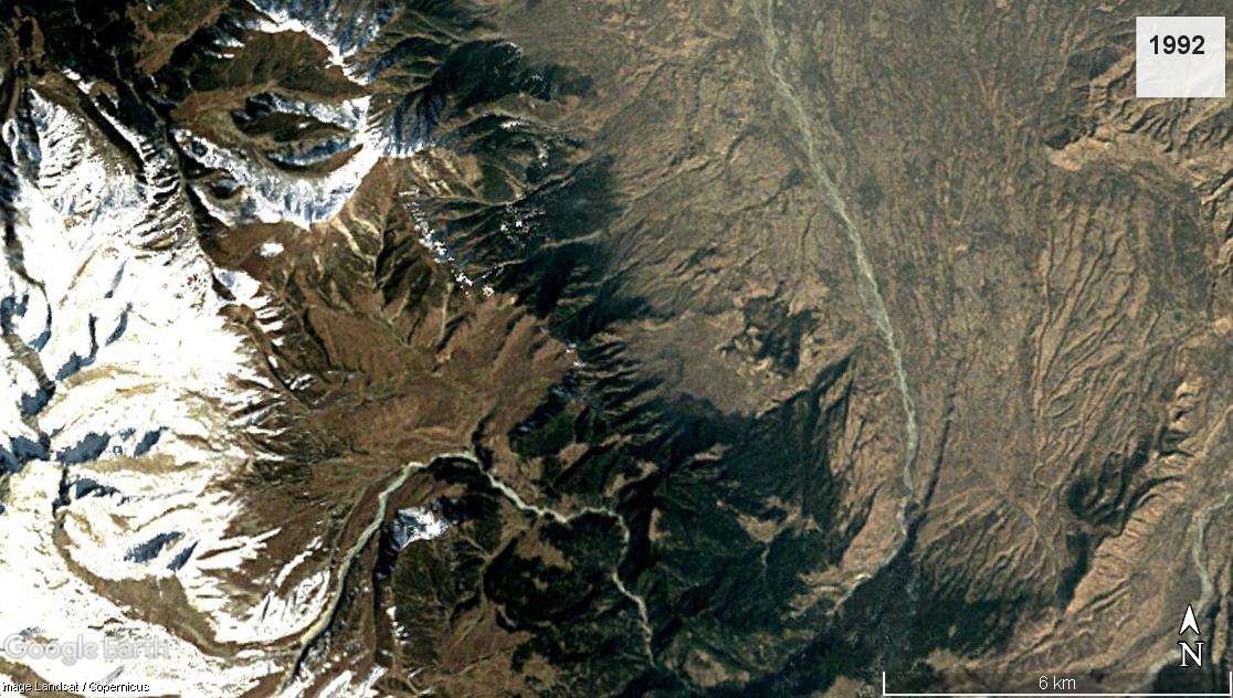 Tosamaidan in 1992
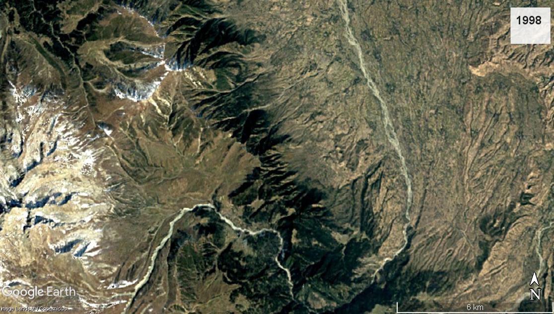 Tosamaidan In 1998
 Tosamaidan in 2007
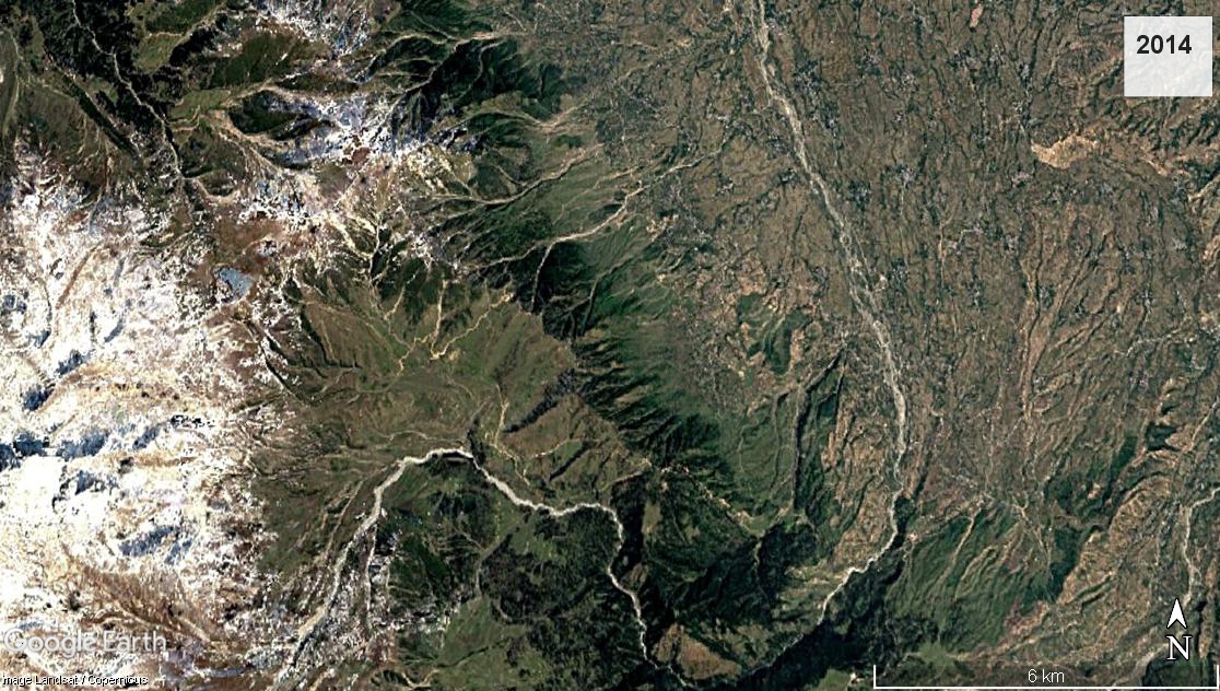 Tosamaidan in 2014
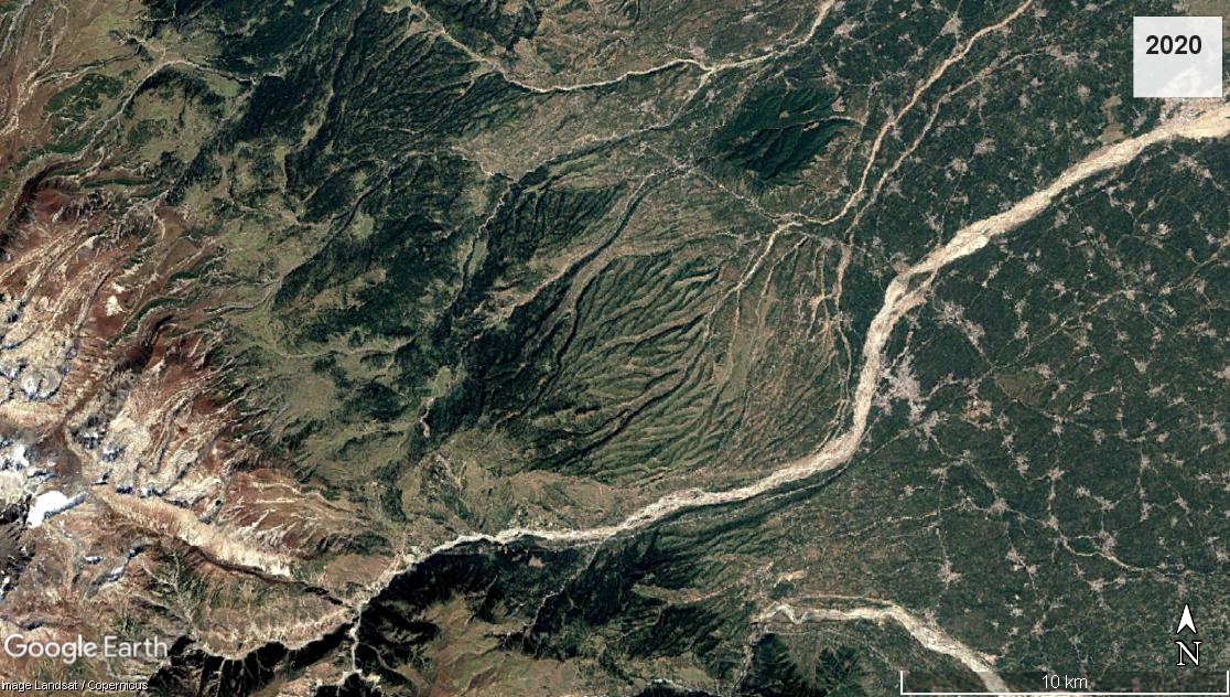
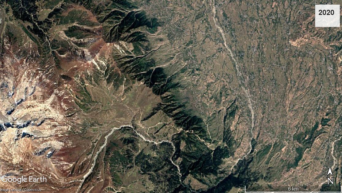 Tosamaidan In 2020
The research has come out at a time when scientists say Kashmir’s climate change is directly linked with the massive deforestation as its ecology has been severely impacted.
The satellite data further show that the dense forest decline is the result of weather extremes, habitat fragmentation, increased man-animal conflict and enhanced soil erosion in the region.
Most of the deforestation has happened in the Pir Panjal range, areas of Shopian, Tosamaidan, Kulgam, Kounsernag, Peer ki Gali along its subrange of Zabarwan among Nishat, Harmukh, Gangabal, Sonamarg, Tral and Pahalgam areas.
“We’ve lost a lot of pine-shaped natural coniferous cover in Kulgam and Shopian and, unfortunately, huge deforestation is still prevalent today,” Dr. Rashid said.
Despite being protected under law, smuggling of Kashmir woods remains a major challenge.
“I visit these deep forests thrice in a year for field study and it’s not easy to understand who the real looters are,” the scientist said. “Such is the smuggling nexus that areas like Tosamaidan far from the human intervention and settlements have recorded massive deforestation.”
Much of this massive axing is driven by the fact that almost 80 per cent of the Kashmir forests are coniferous trees and pyramidal ‘Cedrus Deodar’ costing Rs. 5000 per cubic feet.
“Among other things, this ageless timber sustains the iconic houseboat industry of Kashmir,” the scientist said.
“Another important species of our forests is Texas. It has anti-cancerous oil called Taxol and is found in Gulmarg areas. And then in Chenab Valley, we find a dry fruit that costs Rs. 2000 per kilogram. All such species are important for number of reasons. We should not lose them to deforestation.”
Perched in the Pir Panjal Range and the Great Himalayas, Kashmir valley is known as the “Paradise on Earth” due to its forested mountains, lakes, waterways, gushing springs, glaciers and moderate climate.
However, the unchecked tree felling is now pushing the same serene region into a climate change path. And the impact is already telling.
Srinagar recently recorded the coldest day of June in nearly five decades at 14 Degree Celsius, a temperature very common in February and the night temperature was below 10 degrees.
Other parts, including Gurez, upper reaches of south and north Kashmir received fresh snowfall in the mid-June. Moreover, in January 2022, early sprouting of flowers was also visible.
Similarly, an untimely snowfall in the month of October last year hit the apple growers, followed by scanty snowfall during the harshest winter period. The region also reported 80 per cent rain deficit and bizarre humidity in the spring. Flash floods and hailstorms followed in many parts of Kashmir.
Early snowfalls in Kashmir, where almost 80 per cent of India’s apples are grown, have seen the region’s farmers lose half their crops in the third year of disastrous harvests.
Moreover, an unprecedented hailstorm lately damaged several apple orchards in South Kashmir during the stage two of fruit development.
During that crucial stage, apples are grown of walnut size and any damage leads to the death of whole apple production. Almost 70 per cent of Kashmir population depends on apple production for their livelihood.
Earlier, the metrological department stated that the region has recorded 80 per cent rainfall deficit in the month of March.
Climate grids for future simulations (1990–2098) showed an increasing trend in all hot extreme events but no significant trend in cold extremes, as per a research.
Moreover, after the semi-autonomous status of J&K was scrapped in summer of 2019, the Forest Advisory Committee in Kashmir gave clearances to about 150 projects for industrial development which experts say is fatal to the ecologically fragile region.
But despite this expert warning, there was no clear sight into the shifting order of Kashmir’s deep forests because neither forest department of the Jammu and Kashmir nor Indian Agricultural Statistics show any clue of extreme deforestation.
In fact, the official data shows that the plantation has grown over the past 30 years among sparse forest.
As per the Forest Survey of India’s (FSI) 2017 report, forest cover in Jammu and Kashmir has increased with a net gain of 253 square kilometer, as compared to the forest cover in 2015.
But the method adopted by the report is questionable in its estimate of the total forest cover.
The definition of ‘forest cover’ makes it a land more than 0.01 square kilometer (one hectare) with a tree canopy density of more than 10 per cent, notwithstanding the legal status of the land.
Thus, the Recorded Forest Area (RFA) by the FSI includes land that is legally considered a forest, as per government records, regardless of the actual canopy density.
In other words, if forest land is diverted for dam construction, the legal status of same may remain unchanged.
In view of expert researchers working on the subject, RFA could include land which belongs to the local forest department but has no forest.
But even as the FSI’s 2017 report defines ‘Forest Cover’ as a one-hectare land with more than 10 per cent tree density, authorities in Kashmir consider the 400 per cent surge of apple orchard areas as sparse forests “because people have shifted their farming choices for the sake of financial feasibility whereas the dense cover keeps declines without any notice,” Dr. Rashid.
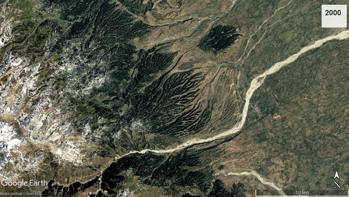 Shopian Forest Belt In 2000
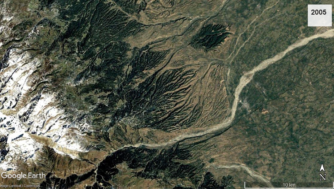 2005
2005
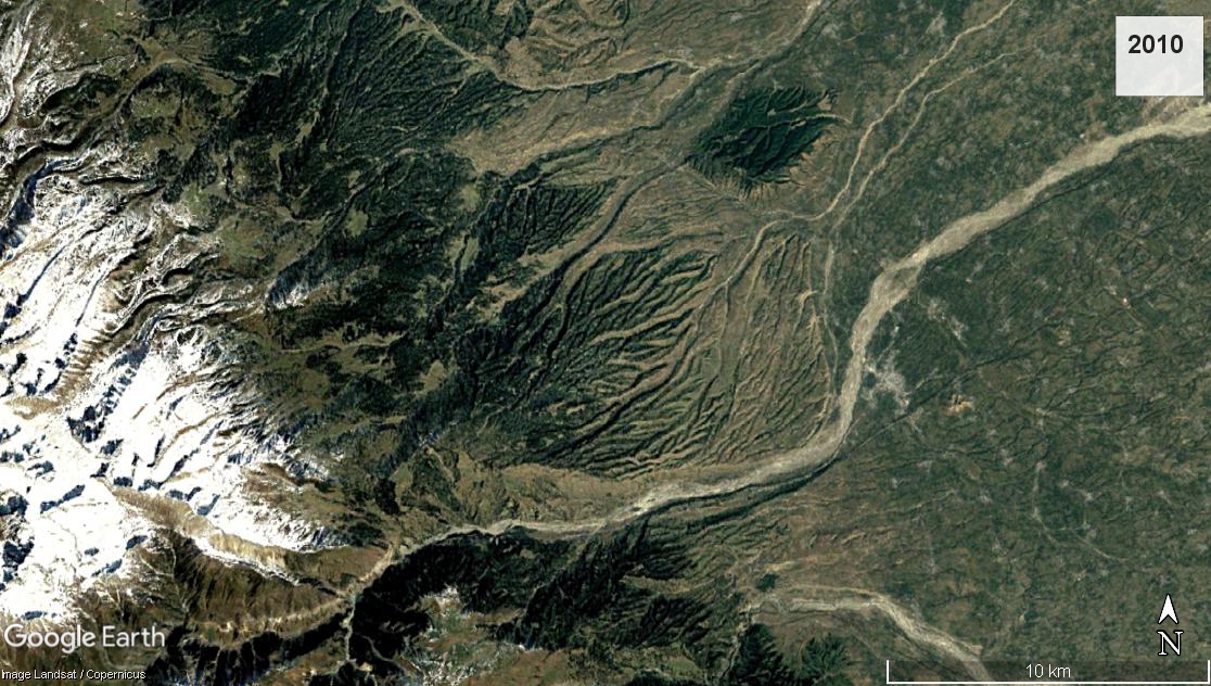 2010
2010
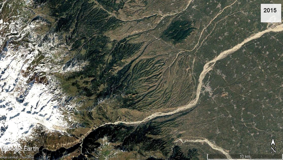 2015
2015
 2020
2020
Geologically, the scientist said, the environment is connected and that’s why the depth of wetlands has decreased in Kashmir because of excessive silt coming down from the upper catchment areas of forests due to dense forest deforestation.
During the past few decades, tourism and urbanization has also degraded forests by increasing the sediment load in the Jhelum.
“It hence becomes imperative to scientifically assess the carrying capacity of the Kashmir valley in general and tourist places in particular,” Dr. Rashid said.
“That will ensure the sustainability of environmental goods and services that the river Jhelum provides for the region.”